
[คละรุ่น] Ublox NEO-M8xx GPS Module (SMA Connector) (คละรุ่น M8L / M8M / M8N)
![[คละรุ่น] Ublox NEO-M8xx GPS Module (SMA Connector) (คละรุ่น M8L / M8M / M8N)](https://o.lnwfile.com/_/o/_raw/ak/bx/cn.jpg)
![[คละรุ่น] Ublox NEO-M8xx GPS Module (SMA Connector) (คละรุ่น M8L / M8M / M8N)](https://o.lnwfile.com/_/o/_raw/yz/8s/a9.jpg)
![[คละรุ่น] Ublox NEO-M8xx GPS Module (SMA Connector) (คละรุ่น M8L / M8M / M8N)](https://o.lnwfile.com/_/o/_raw/w7/6p/5i.jpg)
![[คละรุ่น] Ublox NEO-M8xx GPS Module (SMA Connector) (คละรุ่น M8L / M8M / M8N)](https://o.lnwfile.com/_/o/_raw/k3/yz/yh.jpg)
![[คละรุ่น] Ublox NEO-M8xx GPS Module (SMA Connector) (คละรุ่น M8L / M8M / M8N)](https://o.lnwfile.com/_/o/_raw/a2/ru/gx.jpg)
![[คละรุ่น] Ublox NEO-M8xx GPS Module (SMA Connector) (คละรุ่น M8L / M8M / M8N)](https://o.lnwfile.com/_/o/_raw/gz/fq/u4.jpg)
![[คละรุ่น] Ublox NEO-M8xx GPS Module (SMA Connector) (คละรุ่น M8L / M8M / M8N)](https://o.lnwfile.com/_/o/_raw/ox/ds/il.jpg)
![[คละรุ่น] Ublox NEO-M8xx GPS Module (SMA Connector) (คละรุ่น M8L / M8M / M8N)](https://o.lnwfile.com/_/o/_raw/ph/kc/cq.jpg)
![[คละรุ่น] Ublox NEO-M8xx GPS Module (SMA Connector) (คละรุ่น M8L / M8M / M8N)](https://o.lnwfile.com/_/o/_raw/c2/cv/tw.jpg)
![[คละรุ่น] Ublox NEO-M8xx GPS Module (SMA Connector) (คละรุ่น M8L / M8M / M8N)](https://o.lnwfile.com/_/o/_raw/01/og/jt.jpg)
![[คละรุ่น] Ublox NEO-M8xx GPS Module (SMA Connector) (คละรุ่น M8L / M8M / M8N)](https://o.lnwfile.com/_/o/_raw/vl/qm/d8.jpg)
![[คละรุ่น] Ublox NEO-M8xx GPS Module (SMA Connector) (คละรุ่น M8L / M8M / M8N)](https://o.lnwfile.com/_/o/_raw/by/ca/al.jpg)
| รหัสสินค้า | AS70195 |
| หมวดหมู่ | Receiver/RTK/Timing |
| ราคา | 430.00 บาท |
| สถานะสินค้า | พร้อมส่ง |
| จำนวน | ชิ้น |

รายละเอียดสินค้า
หมายเหตุ:
- สินค้าคละรุ่นของ GPS เช่น ลูกค้าอาจจะได้รับ M8L หรือ M8M หรือ M8N ไม่สามารถเลือกรุ่นได้
- สินค้าไม่รวมเสาอากาศ แนะนำให้ใช้ร่วมกับ สายอากาศ GPS รหัส AS00046
- Product Summary : M8N / M8N / M8J / M8Q
- Product Summary : M8L(M8L-xxA และ M8L-06B)
- เอกสารอื่นๆ M8N / M8N / M8J / M8Q
- เอกสารอื่นๆ M8L
NEO-M8L-xxA:
u-blox M8 GNSS LCC module with 3D dead reckoning and onboard sensors, TCXO, Automotive Grade - End of Life
NEO-M8L-06B:
u-blox M8 GNSS LCC module with 3D dead reckoning and onboard sensors, crystal, Professional Grade
NEO-M8M-0:
u-blox M8 GNSS module ROM, crystal LCC
NEO-M8N-0:
u-blox M8 GNSS module Flash TCXO, SAW, LNA LCC
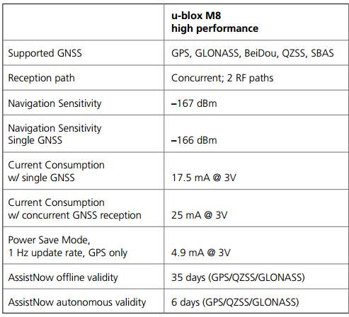
Ublox NEO-M8M เป็น GPS Module ที่มีประสิทธิภาพสูงสุดของ Ublox ณ ปัจจุบันนี้ โดยสามารถทำการ Tracke ระบบนำทาง 2 ระบบได้ในเวลาเดียวกัน (by default จะเป็น GPS และ GNSS) ซึ่งต่างจาก Ublox รุ่นก่อน ที่ไม่สามารถทำได้ นอกจากนั้นยัง support ระบบ BeiDou (ระบบนำทางของ จีน), ระบบ SBAS และ ระบบ QZSS อีกด้วย
*** แจ้งเราทางอีเมล์หากต้องการ source code ที่ทางร้านได้จัดเตรียมไว้สำหรับลูกค้าที่ซื้อ GPS Module ตัวนี้ไป โดยผลการรันจะแจ้งค่า Latitude Longitude วัน/เวลา และค่าอื่นๆที่สำคัญ ครบถ้วน สามารถนำไปต่อยอดประยุกต์ใช้งานได้หลายแบบ ***
ตัวอย่างการต่อและการใช้งาน:
อ้างอิง: https://randomnerdtutorials.com/arduino-neo-m8n-gps-module/
Wiring the NEO-M8N GPS Module to the Arduino
To communicate with the NEO-6M GPS module, we’ll use software serial, so you can use any available Pins. We’ll use Pin5 (TX –> connects to the module RX) and Pin6 (RX –> connects to the module TX).

| NEO-M8N GPS Module | Arduino |
| VCC | 5V |
| RX | Pin 5 |
| TX | Pin 6 |
| GND | GND |
Getting Raw GPS Data – Testing the NEO-M8N GPS Module with the Arduino
To get raw GPS data you need to start a serial communication with the GPS module and read the available data.

The following code establishes a serial communication with the GPS module and reads the available data.
/*
Rui Santos & Sara Santos - Random Nerd Tutorials
Complete project details at https://RandomNerdTutorials.com/arduino-neo-m8n-gps-module/
Permission is hereby granted, free of charge, to any person obtaining a copy of this software and associated documentation files.
The above copyright notice and this permission notice shall be included in all copies or substantial portions of the Software.
*/

#include <SoftwareSerial.h>

static const int RXPin = 6, TXPin = 5;
static const uint32_t GPSBaud = 9600;

// The serial connection to the GPS module
SoftwareSerial gpsSerial(RXPin, TXPin);

void setup(){
Serial.begin(9600);
gpsSerial.begin(GPSBaud);
}

void loop(){
while (gpsSerial.available() > 0){
// get the byte data from the GPS
byte gpsData = gpsSerial.read();
Serial.write(gpsData);
}
}
How Does the Code Work?
This sketch assumes you are using Pin 6 and Pin 5 as RX and TX serial pins to establish serial communication with the GPS module. If you’re using other pins you should edit that on the following lines:
static const int RXPin = 6, TXPin = 5;Also, if your module uses a different default baud rate than 9600 bps, you should modify the code on the following line:
static const uint32_t GPSBaud = 9600;Then, we create an instance of the SoftwareSerial on the pins defined earlier called gpsSerial.
// The serial connection to the GPS device
SoftwareSerial gpsSerial(RXPin, TXPin);
In the setup(), we initiate the Serial Monitor.
Serial.begin(9600);Then, we initialize a serial communication with the GPS module.
gpsSerial.begin(GPSBaud);In the loop(), the code listens to the GPS serial port, and when data is received from the module, it is printed in the serial monitor.
void loop(){
while (gpsSerial.available() > 0){
// get the byte data from the GPS
byte gpsData = gpsSerial.read();
Serial.write(gpsData);
}
}Upload the code to your board.

Make sure the antenna is connected and that the module or antenna is placed outside or next to a window so that it can get data from the satellites.

The module’s blue LED will start blinking when it finds a position fix.
The Serial Monitor will display NMEA sentences with GPS data (make sure to select the Serial Monitor baud rate to 9600).
Important: If you’re running this sketch for the first time, it may take a few minutes until the module gets a position fix. You’ll start getting actual data when the blue LED starts blinking. If you’re inside a building, it is very unlikely that you can get GPS data. Go outside or place your antenna outside to maximize your chances of catching a satellite signal.

You should get a bunch of information in the GPS standard language, NMEA. Each line you get in the serial monitor is an NMEA sentence.
NMEA stands for National Marine Electronics Association, and in the world of GPS, it is a standard data format supported by GPS manufacturers.
NMEA Sentences
NMEA sentences start with the $ character, and each data field is separated by a comma.
$GNRMC,115209.00,A,4114.5500,N,00861.4900,W,0.129,,160125,,,D*XX
$GNVTG,,T,,M,0.129,N,0.239,K,D*XX
$GNGGA,115209.00,4114.5500,N,00861.4900,W,2,10,0.93,130.6,M,50.1,M,,0000*XX
$GNGSA,A,3,24,25,28,32,29,,,,,,,,1.65,0.93,1.37*XX
$GNGSA,A,3,78,66,67,77,,86,26,083,20*XX
$GLGSV,3,3,09,87,13,131,*XX
$GNGLL,4114.5500,N,00861.4900,W,115209.00,A,D*XX
There are different types of NMEA sentences. The type of message is indicated by the characters before the first comma.
The GN after the $ indicates it is a GPS position. The $GNGGA is the basic GNSS NMEA message, that provides 3D location and accuracy data.
In the following sentence:
$GNGGA,110827.00,4114.32485,N,00831.79799,W,1,10,0.93,130.6,M,50.1,M,,*5F
Here’s how the fields look for the M8N:
- $GNGGA: Global GNSS location data.
- 110827.00: Time in UTC (11:08:27).
- 4114.32485,N: Latitude.
- 00831.79799,W: Longitude.
- 1: Fix quality (1 = GPS fix, 2 = DGPS, etc.).
- 10: Number of satellites tracked (higher for M8N compared to NEO-6M).
- 0.93: Horizontal dilution of precision (lower is better).
- 130.6,M: Altitude above mean sea level (in meters).
- 50.1,M: Height of geoid above the WGS84 ellipsoid.
- *5F: Recalculated checksum for the NEO-M8N.
The other NMEA sentences provide additional information:
- $GNRMC – Essential GNSS PVT (Position, Velocity, Time) data
- $GNVTG – Velocity and track information
- $GNGGA – GNSS Fix Information
- $GNGSA – GNSS DOP and active satellites
- $GLGSV – Detailed satellite information (GLONASS)
- $GNGLL – Geographic Latitude and Longitude.
วิธีการชำระเงิน
ชำระเงินค่าสินค้าโดยการโอนเงินเข้าบัญชีธนาคาร KBANK, SCB, BBL,TMB
กรุณาเก็บหลักฐานการโอนเงินของท่านไว้เพื่อแจ้งการชำระเงินด้วยค่ะ
ท่านสามารถแจ้งการชำระเงินผ่านระบบอัตโนมัติได้โดย Click Link ข้างล่างค่ะ
https://www.arduitronics.com/informpayment
ชำระเงินผ่านธนาคาร


@rfm0967y
ติดต่อสอบถาม
Join เป็นสมาชิกร้านค้า
MEMBER
